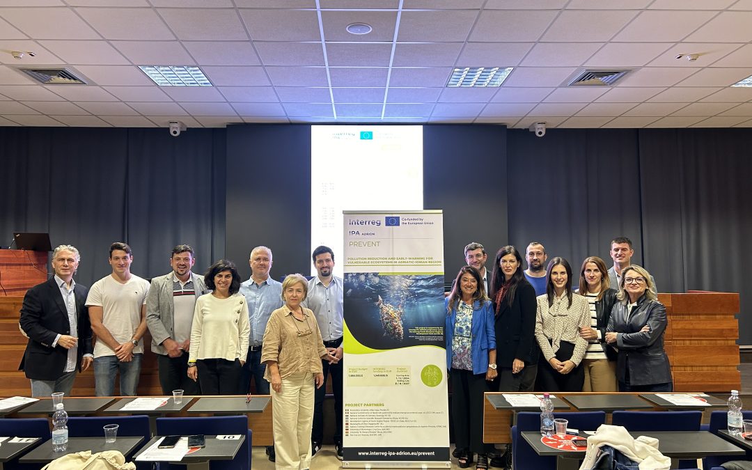
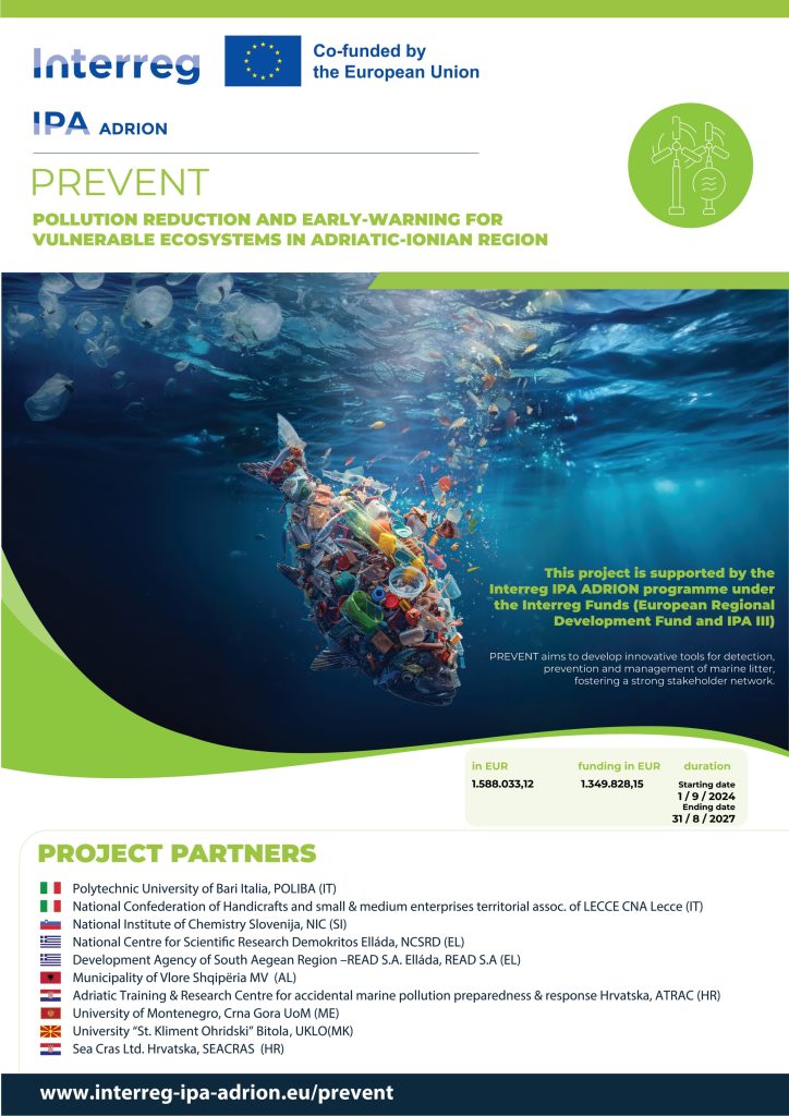
SeaCras is one of the consortium of partners that are conducting the Pollution Reduction and Early-warning for Vulnerable Ecosystem in Adriatic-lonian Territories — PREVENT project, funded by the European Commission’s IPA ADRION 419.
This project, with Politecnico di Bari as the project leading institution, addresses the common challenge of marine pollution in the Adriatic-Ionian region. This challenge is exacerbated by climatic changes and poses a significant threat to the region’s ecosystems, communities, and economies.
The aim of this initiative is to develop innovative tools and methods for early detection, prevention, and management of marine litter, ultimately establishing a robust network of stakeholders:
Pilot Action: Early Detection System for Marine Pollution
Pilot Action: Marine Litter Forecasting Model
Joint Solution: Sustainable Methodology for Reusing Plastics from Marine Litter
Joint Solution: Transnational Marine Litter Management System (JTMLMS)
Pilot Action: Developing an efficient, eco-friendly method for reusing plastic waste
Joint Marine Litter Prevention and Management Strategy (JMLPMS)
Climate Resilient Adriatic-Ionian Action Plan (CRAIAP)
What sets the PREVENT project apart is its comprehensive and integrated approach to marine litter management. The project combines innovative technologies, such as early detection systems and forecasting models, with knowledge-sharing platforms, policy recommendations, and capacity-building activities.
By integrating scientific research, community engagement, and policy development, the project aims to create a lasting impact on the region’s marine ecosystem, enhance its resilience to climate change, and contribute to the sustainable development of the Adriatic-Ionian region.
The project, funded by the European Commission with a total budget of €1,588,033, includes a budget allocation of €136,750 for SeaCras.
Owing to that, and as part of PREVENT, SeaCras will implement its technologies across a broader area of the Croatian islands Mljet and Korcula, as well as in the Bay of Kotor in Montenegro.
Discussions about protecting the environment and preserving natural resources as well as warnings about the growing soil, air, and marine pollution, along with environmental degradation, is becoming an increasingly prominent topic in public discourse.
These initiatives, debates, and educational efforts are vital as they remind us of our responsibility to future generations. Through collective efforts, innovation, and sustainable practices, we can lay the foundation for a healthier and cleaner environment.
It’s expected that a quarry located near the coastline would have some impact on the seabed and water column. However, several questions remain:
1) Can we accurately assess the extent of this impact? 2) Can we provide quantitative evidence to support the term “ecocide”? 3) Moreover, is the damage localized, or does its influence extend far beyond?
Even a quick glance at Google Maps reveals that the shallow waters near the shore are covered in fine sediments originating from the quarry. Yet, beneath the surface lies a wealth of details that the naked eye cannot detect.
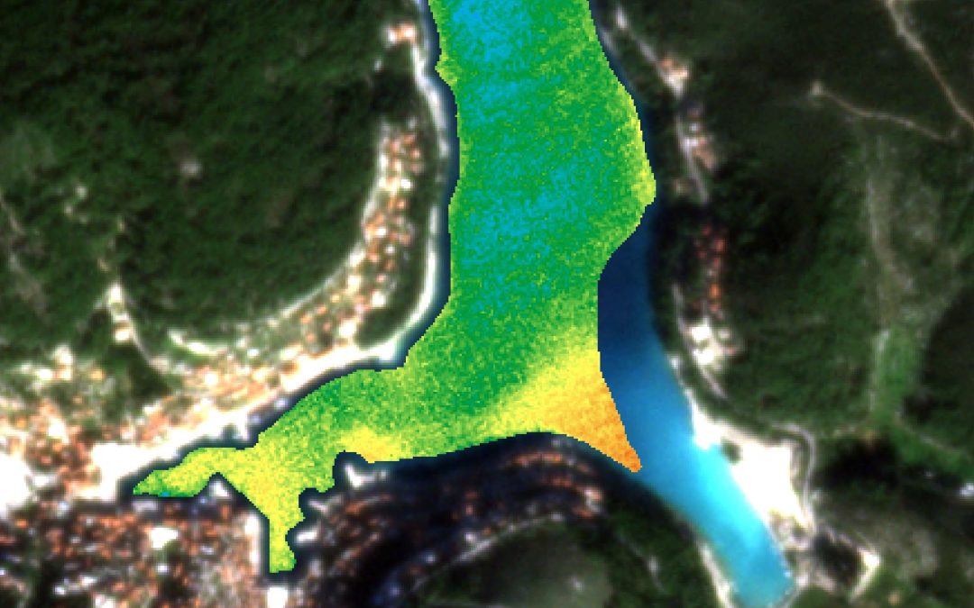
We conducted a study using our AI-powered analysis of high-resolution satellite data to examine the quarry’s impact on the marine water column. Some results are presented in images 1) and 2).
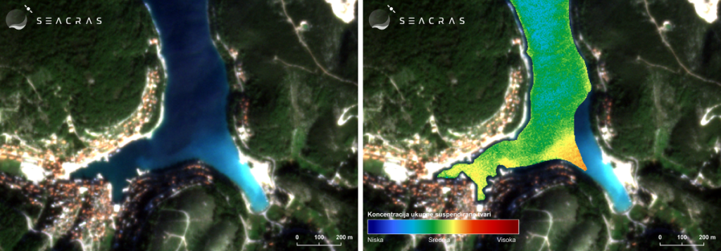
Image 1) Satellite image of the Pučišća area on the island of Brač (left) and a thematic map showing the quantitative measurement of suspended matter concentration in the water column using SeaCras AI algorithms, dated November 8, 2024 (right).
Image 1) shows a scenario of relatively calm weather with no wind.
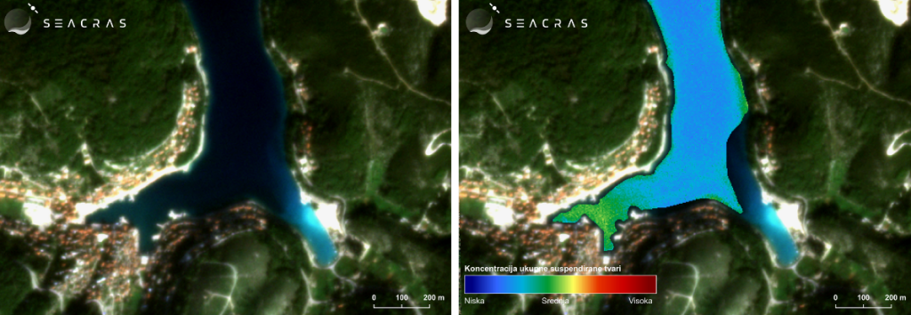
Image 2) Satellite image of the Pučišća area on the island of Brač (left) and a thematic map showing the quantitative measurement of suspended matter concentration in the water column using SeaCras AI algorithms, dated November 15, 2024 (right).
Image 2) depicts conditions under the influence of strong bora wind, blowing from the northeast (NE), across the wider area of the island Brač.
The true scope of the problem becomes evident in image 2). The results from our AI analysis quantitatively demonstrate a dramatic increase in suspended matter concentration in the water column. The measured concentration of suspended matter in the middle of the bay (image 2)) is five times higher than that observed in image 1), on dates where there is no wind. Furthermore, near the southern shore, this increase exceeds tenfold.
Additionally, the zone of impact is quantifiable and encompasses the entire bay, revealing a much broader area of influence than what local residents might observe!
The root cause of this issue, which likely occurs periodically, is the strong bora wind carrying material from the quarry located on the northeastern side of the island. The bora spreads this material across a wider area, with a significant portion ending up in the sea, covering the entire bay with substantial deposits.
This natural phenomenon of marine pollution is further exacerbated by urbanization, which often results in larger amounts of inadequately managed construction and industrial waste. This compromises seawater quality and disrupts the natural balance of the marine ecosystem. Our solutions for detecting and monitoring marine turbidityleverage advanced satellite technology and data analytics to precisely track the impacts of such events. This enables timely access to critical information necessary for implementing environmental conservation measures and sustainable coastal management.
Over the years, the cumulative effect has been devastating to the marine environment, as deposits ‘smother’ the seabed and degrade its habitat. While physicochemical indicators of seawater quality periodically point to poor conditions, microbiological quality remains unaffected by these influences.
Using our technology, we addressed all the aforementioned questions and concluded that this represents a form of slow ecocide. However, it is also crucial to recognize that traditional environmental and impact assessments, while based on textbook knowledge, often fail to anticipate unexpected scenarios, particularly in the context of climate change.
Effectively addressing the devastation of marine ecosystems, the impacts of human activities, climate change, pollution, and the degradation of the biosphere on a broader scale requires a comprehensive and strategic approach. Key components of such an approach include continuous monitoring, trend analysis, and the prediction of future scenarios, all grounded in the use of advanced technologies like environmental digital twins. These tools enable precise tracking, comparison, and modeling of future impacts, providing a solid foundation for sustainable and effective decision-making.
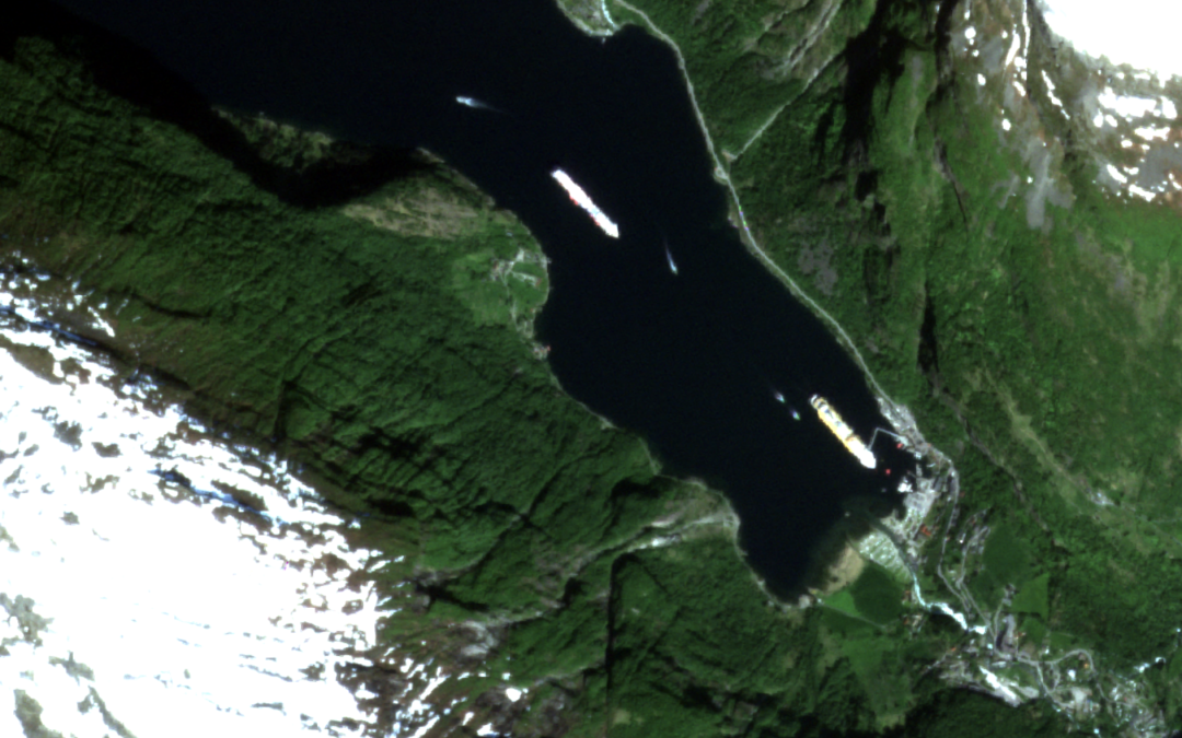
SeaCras, in partnership with Smeco AS, is currently conducting a bilateral project titled ‘Feasibility Study for SeaCras’s Earth Observation-Enabled Products to Foster Sustainable Blue Growth and Norway’s Coastal Tourism’. This project is funded by Innovation Norway under the name ‘Bilateral Cooperation in Green and Blue Sectors Between Croatia and Norway’.
The project’s goal is not only to test the value proposition of SeaCras products, designed and developed for stakeholders in the cruising industry, maritime transport, and coastal tourism, but also to complement it with an actual demonstration study of marine emissions across a network of locations, including ports, fjords, and protected marine areas.
Through the implementation of the SeaCras system across multiple locations in Norway, along with Smeco AS’s network connections and dissemination activities, a groundbreaking large-scale study of marine emissions from cruise ships and port operators across entire destinations is being developed and articulated among stakeholders. The new era of sustainable business demands that environmental assessments be integrated into business models. Consequently, feasibility studies as strategic documents must evolve to reflect this shift.
SeaCras’s unique value lies in its ability to monitor dozens of locations simultaneously. This capability provides an unparalleled perspective on the interplay between cruising and tourism business operations and their impact on the marine environment in Norwegian fjords, bays, and coastlines.
Studies like this will be crucial for the sustainable development of the cruising industry. Future projects will expand to large-scale studies in the Adriatic, Mediterranean, Caribbean, Red Sea, and beyond.
As promised, part of the results will be published in the UN Ocean Prediction Atlas to encourage community involvement in conservation and restoration projects, as well as to promote open data and open science practices.
We extend our gratitude to Innovation Norway for their support through grants, mentorship, and continuous collaboration.