

The wildfire that broke out in Lokva Rogoznica in the early evening of 13 August 2026 and spread across the coastal area between Omiš and Mimice left consequences that extend far beyond the size of the area directly affected by the fire.
Before we continue, we want to acknowledge the human impact of this tragedy. Our thoughts are with the families and loved ones of those who lost their lives, everyone who was injured, and all those whose homes and lives have been affected by the fire.This was one of the most severe wildfires to affect the Croatian coast in the past decade, leaving behind destroyed and damaged homes, infrastructure and natural habitats, as well as consequences that will continue to be felt long after the flames have been extinguished.
To support the remediation and recovery of the affected area, SeaCras conducted this study for the public good, with the aim of providing a clearer understanding of the scale of the damage and supporting the planning of appropriate recovery, remediation and assistance measures.
The following satellite and spatial analysis shows how the impacts of the event overlap with natural habitats, built-up areas, tourism infrastructure and steep slopes, where monitoring erosion and surface runoff becomes increasingly important after a wildfire.
Satellite imagery reveals the scale of change
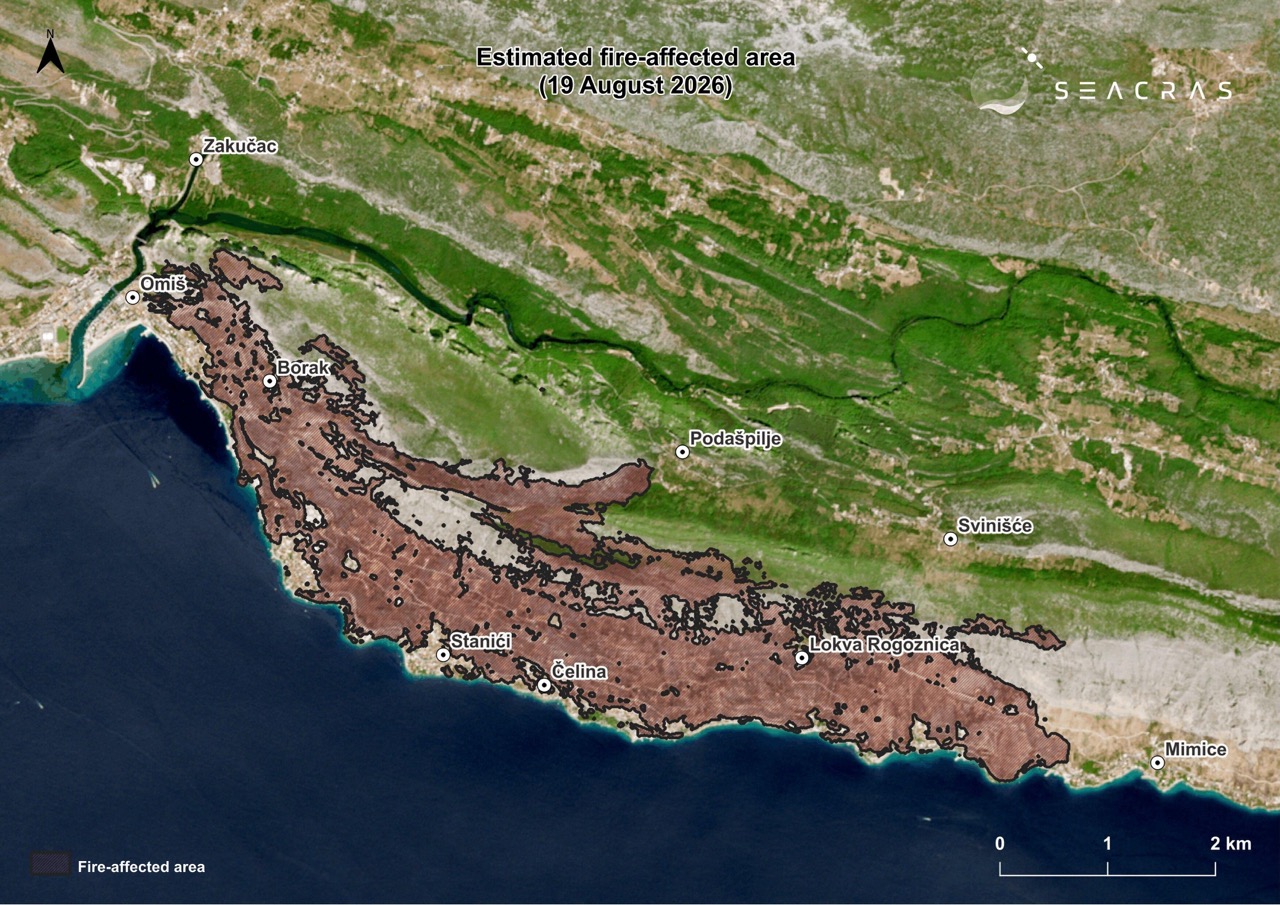
Figure 1. Estimated area affected by the wildfire in the Omiš and Mimice area, image date: 19 August 2026. (Data source: Copernicus Sentinel-2; processing: SeaCras)
Figure 1 shows the estimated fire-affected area as of 19 August 2026, covering approximately 1,030 hectares. The affected area extends across the steep southern and coastal slopes of Omiška Dinara above Omiš, Nemira, Stanići, Čelina and Lokva Rogoznica. The analysis combines multi-temporal satellite imagery, indicators of vegetation change and burn severity, as well as spatial data on habitats, buildings, tourism, spatial plans and terrain.
These data can help answer a question that becomes particularly important once the fire has been extinguished: what lies within the affected area, how has the surface changed, and where could additional risks emerge?
A comparison of satellite imagery from 11 and 19 August shows a pronounced change in land cover across the southern slopes between Omiš and Mimice. In the post-fire image, areas previously covered by vegetation clearly display spectral characteristics associated with burned vegetation, exposed soil and underlying rock.
Where was the change most pronounced?
Based on satellite interpretation, an estimated fire perimeter of approximately 1,030 hectares was delineated and then used as the primary spatial layer for further overlay analysis with data on habitats, buildings, protected areas and infrastructure.
However, the fire perimeter alone does not indicate the intensity of surface change. The analysis therefore also incorporates spectral indices such as dNBR and dNDVI.
dNBR (Differenced Normalized Burn Ratio) indicates how much the surface spectral signal changed between pre-fire and post-fire imagery. The index uses the near-infrared and short-wave infrared parts of the spectrum, which are particularly sensitive to vegetation condition, moisture content and fire-related changes. Higher positive values generally indicate a more pronounced change associated with burning. [ref. Key, C.H. & Benson, N.C. (2006). Landscape Assessment (LA): Sampling and Analysis Methods. FIREMON, USDA Forest Service, RMRS-GTR-164-CD.]
Tablica 1. dNBR Values and Their Categorisation
| dNBR | Change category |
| < 0,10 | negligible / very low change |
| 0,10–0,27 | low |
| 0,27–0,44 | moderate |
| 0,44–0,66 | moderately high |
| > 0,66 | high |
[ref. Key, C.H. & Benson, N.C. (2006). Landscape Assessment (LA): Sampling and Analysis Methods. FIREMON, USDA Forest Service, RMRS-GTR-164-CD.]
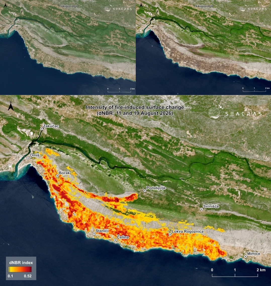
Figure 2. Satellite image of the wider study area on 11 August 2026 (Source: Copernicus Sentinel-2), top left, and satellite image of the wider study area on 19 August 2026 (Source: Copernicus Sentinel-2), top right. The lower image shows the intensity of fire-induced surface change in the Omiš and Mimice area according to the dNBR index, based on a comparison of imagery from 11 and 19 August 2026.
As shown in Figure 2, the highest values within the analysed area occur along the south-eastern part of Omiš, through the Borak – Nemira – Stanići – Čelina – Lokva Rogoznica – Mimice corridor, as well as across the hilly area south-west of Podašpilje. These areas recorded the greatest spectral changes between the pre-fire and post-fire imagery, indicating more pronounced fire-related impacts on vegetation and land cover.
It is important, however, to distinguish between satellite-detected change and confirmed ecological damage. Areas with high dNBR values should be used to prioritise further verification rather than treated as standalone confirmation of the degree of damage without supporting field data.
Additional insight is provided by dNDVI, an indicator of changes in vegetation cover before and after the wildfire. Figures 3 and 4 show the spatial distribution of dNDVI values. Across the analysed area, dNDVI values ranged from -0.33 to 0.88. Values around zero indicate areas where there was no significant change in the vegetation signal between the two images. Positive values indicate a decline in NDVI after the wildfire, with higher values corresponding to a more pronounced loss of vegetation signal.
Areas with elevated dNDVI values can be associated with substantial vegetation loss or damage. These were observed north of Nemira and Čelina and south-west of Podašpilje, precisely in areas that had higher vegetation density before the wildfire. [ref. Yavuz, M. et al. (2023). Mapping burn severity and monitoring CO content in Türkiye’s 2021 Wildfires, using Sentinel-2 and Sentinel-5P satellite data on the GEE platform.]
Tablica 2. dNDVI Values and Their Categorisation
| dNDVI | Change category |
| < 0,07 | very low / negligible |
| 0,08–0,20 | low |
| 0,21–0,33 | moderate |
| 0,34–0,44 | high |
| > 0,44 | very high |
Source: Zahabnazouri et al. (2025).
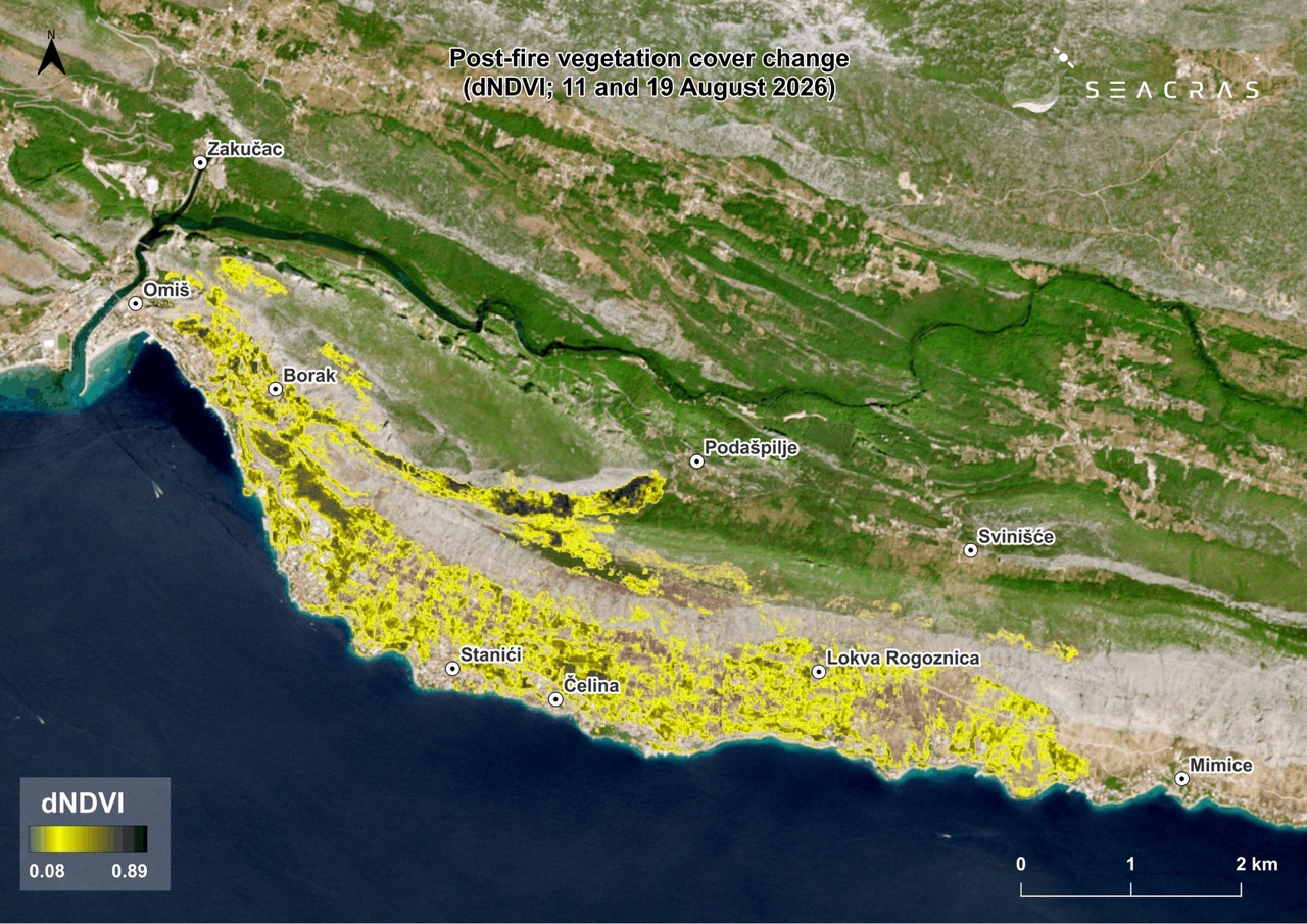
Figure 3. Change in vegetation cover following the wildfire in the Omiš and Mimice area according to the dNDVI index, based on a comparison of imagery from 11 and 19 August 2026. (Data source: Copernicus Sentinel-2; processing: SeaCras)
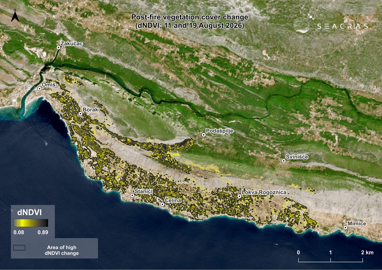
Figure 4. Change in vegetation cover following the wildfire in the Omiš and Mimice area according to the dNDVI index, with the area of high index change highlighted, based on a comparison of imagery from 11 and 19 August 2026. (Data source: Copernicus Sentinel-2; processing: SeaCras)
Around 385 hectares of forest habitats within the fire-affected area
Overlaying the estimated fire-affected area with the habitat map available through Bioportal identified approximately 385 hectares of forest habitats within the affected area. The spatial analysis also makes it possible to distinguish between forest complexes, shrubland, grassland, successional areas and other land-cover types, which differ in their sensitivity to fire and their post-fire recovery dynamics.
The loss or degradation of forest cover is particularly significant because of the role vegetation plays in protecting soil. Forest damage can reduce soil protection, alter microclimatic conditions, fragment habitats and temporarily reduce carbon sequestration capacity.
The analysis also examines the spatial relationship between the affected area and protected natural and cultural assets. The wider area includes Natura 2000 sites, the Cetina Canyon significant landscape and other areas of natural and cultural heritage. According to the spatial overlay analysis of the fire-affected area and the boundaries of the significant landscape, approximately 30 hectares of the affected area fall within the protected landscape, while nearby ecological network sites, the Cetina River and its estuary were within a zone of increased exposure.
The fire-affected area overlaps with densely built-up and tourism areas
One of the key findings of the spatial analysis concerns buildings. Figure 5 shows the spatial distribution of all buildings across the wider study area alongside the dNBR index for the same area. By overlaying the fire-affected area with the locations of all buildings across the wider area, approximately 300 buildings were identified within the fire perimeter, while several hundred more are located immediately adjacent to it. The highest concentrations of affected buildings were identified in densely built-up areas such as the south-eastern part of Omiš and the settlements of Nemira, Stanići and Čelina.
More than 500 accommodation properties were also recorded within or in the immediate vicinity of the fire-affected area, highlighting the extent to which wildfire risk along this part of the coast is closely connected with tourism infrastructure.
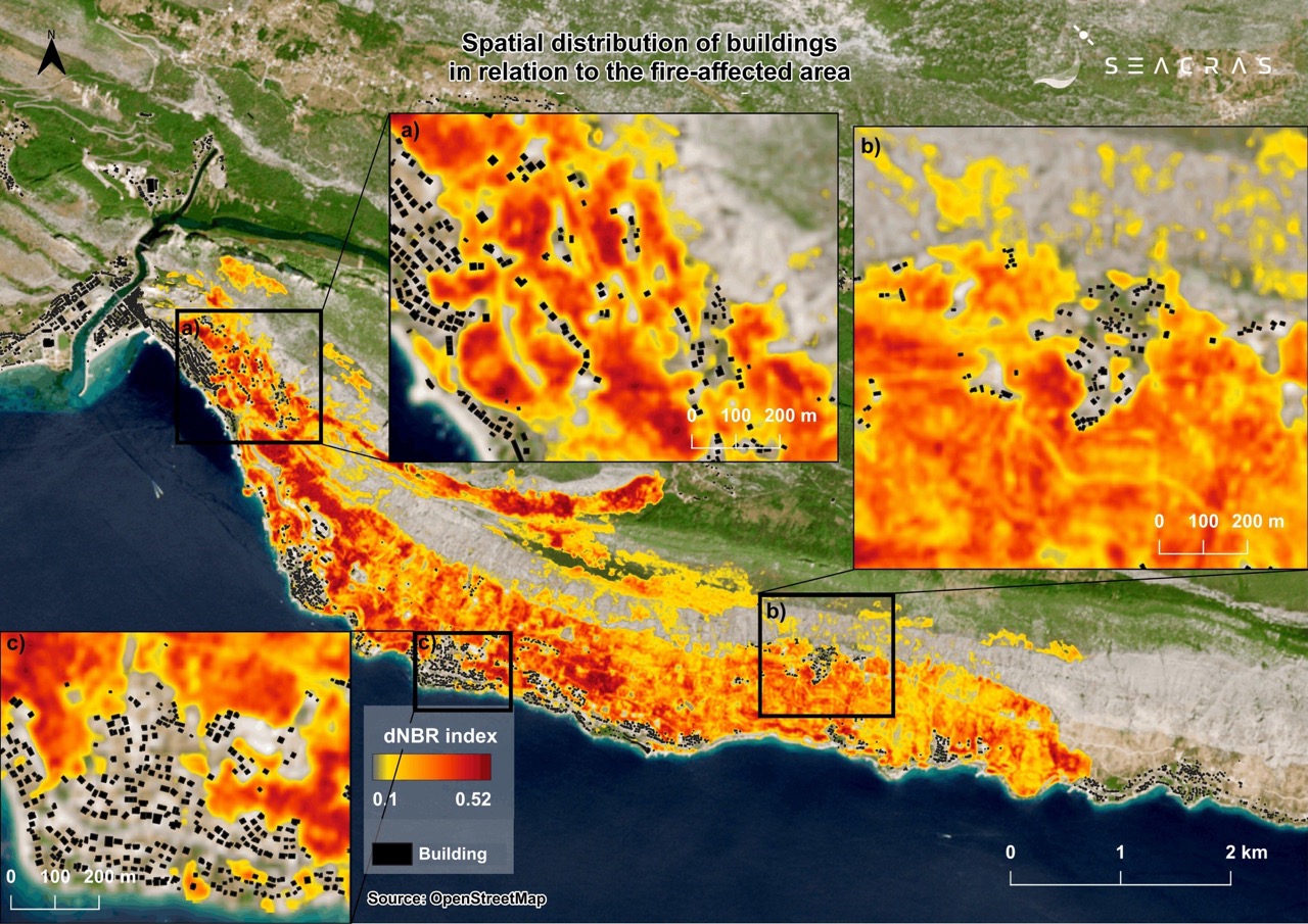
Figure 5. Spatial distribution of buildings in relation to the fire-affected area in the Omiš and Mimice area, showing selected zones (a–c) and the intensity of surface change according to the dNBR index. (Data sources: Copernicus Sentinel-2, OSM; processing: SeaCras)
This dimension is particularly relevant during the summer season. The wider study area has approximately 15,000 permanent residents, while tourism data indicate a substantial seasonal increase in the number of people present. Numerous reports stated that around 12,000 tourists were in the fire-affected area, while the total number of people potentially exposed may have reached as many as 30,000. (Source: Telegram.hr, 15 August 2026.)
After the fire, attention shifts to erosion and surface runoff risks
The period of elevated risk does not necessarily end once the wildfire has been extinguished.
The area between Omiš and Mimice is characterised by steep slopes descending towards settlements, roads and the coastline. Following the loss of vegetation, rainfall can run off downslope more rapidly and more readily mobilise soil, ash and fine material.
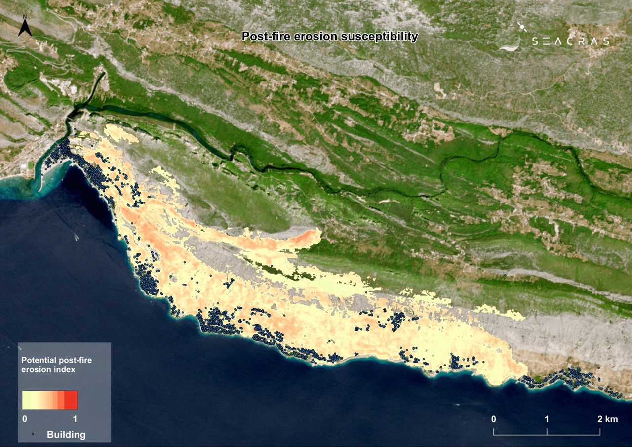
Figure 6. Index of potential post-fire erosion susceptibility in the Omiš and Mimice area, showing buildings within and near the fire-affected area (11–19 August 2026). Higher index values indicate areas where the combination of slope, loss of vegetation signal, intensity of fire-related change and concentration of surface runoff suggests greater relative susceptibility to erosion processes. (Data source: Copernicus Sentinel-2; processing: SeaCras)
Surface runoff accumulation analysis further identifies topographically controlled corridors, such as gullies and drainage pathways, through which water and material may be channelled towards roads, buildings and the sea during intense rainfall.
By combining data on terrain slope, the intensity of fire-related spectral change, loss of vegetation signal and the topographically controlled concentration of surface runoff, an index of potential post-fire erosion susceptibility was developed. The input indicators were normalised to a common relative scale from 0 to 1, allowing them to be compared and spatially combined.
The resulting index does not represent the amount of eroded soil or the probability of erosion occurring. Instead, it serves as a screening indicator that highlights areas where multiple factors conducive to post-fire erosion processes coincide. As shown in Figure 6, the highest index values occur on the slopes north of Nemira and Stanići and south-west of Podašpilje.
The index can therefore help identify priority areas for field inspections, preventive measures and monitoring following intense rainfall. [ref. Efthimiou, N., Psomiadis, E. & Panagos, P. (2020). Fire severity and soil erosion susceptibility mapping using multi-temporal Earth Observation data: The case of Mati fatal wildfire in Eastern Attica, Greece. Catena, 187, 104320.]
Satellite monitoring can show where recovery is taking place – and where it is not
Proposed next steps include multi-year monitoring of satellite indicators such as NDVI, NBR/dNBR and NDMI, analysis of vegetation signal recovery across different habitat types, and verification of areas with high erosion susceptibility following intense rainfall. Particular attention should be paid to steep slopes above settlements, roads and the coastal zone.
Following extreme events, satellite and GIS data make it possible to view a wildfire not simply as an area that has burned, but as a spatial event whose impacts simultaneously affect vegetation, infrastructure, people and tourism, as well as secondary processes that may only become significant after the first major rainfall events.
For the Omiš and Mimice area, the next important question is therefore not simply how much land was affected, but where vegetation is recovering, where recovery is lagging behind, and where environmental vulnerability overlaps with the exposure of people and property.
Continuous spatial monitoring is precisely what can make these differences measurable and operationally useful.
This study, the photographs and the analysis are being shared for the public good and to support the recovery of the region, and may therefore be freely used for those purposes.
Sources:
- Key, C.H. & Benson, N.C. (2006). Landscape Assessment (LA): Sampling and Analysis Methods. FIREMON, USDA Forest Service, RMRS-GTR-164-CD.
- Yavuz, M. et al. (2023). Mapping burn severity and monitoring CO content in Türkiye’s 2021 Wildfires, using Sentinel-2 and Sentinel-5P satellite data on the GEE platform.
- Efthimiou, N., Psomiadis, E. & Panagos, P. (2020). Fire severity and soil erosion susceptibility mapping using multi-temporal Earth Observation data: The case of Mati fatal wildfire in Eastern Attica, Greece. Catena, 187, 104320.
- Zahabnazouri, S., Belmont, P., David, S., Wigand, P. E., Elia, M. & Capolongo, D. (2025). Detecting Burn Severity and Vegetation Recovery After Fire Using dNBR and dNDVI Indices: Insight from the Bosco Difesa Grande, Gravina in Southern Italy. Sensors, 25(10), 3097. https://doi.org/10.3390/s25103097.
- https://www.telegram.hr/vijesti/strani-mediji-zatrpali-hrvatsku-pitanjima-o-pozarima-ministarstvo-i-htz-krenuli-u-akciju-kontrole-stete/
- browser.dataspace.copernicus.eu