SeaCras App –
interactive map
of sea quality
Easy-to-use tool for businesses that manage their ocean footprint and proudly showcase their efforts. From the world of maritime and leisure, crafted for residents and guests.

Earn customers’ and locals’ trust and control your sea emissions.
Demonstrate your sustainability efforts in the desired area to the community.

Anywhere in the world

Tool to showcase your actions

Most affordable solution on the market

API integrations with websites and apps
Daily satellite image of your desired area's water quality, easily accessible from any device.
SeaCras App is an opportunity to present what you REALLY do for the environment.

Engage your customers by providing them with a tool to check water quality themselves.
Just one QR code scan is all it takes to access daily images!

Changes in the marine environment over time

Compatible with all devices

User-friendly & designed for all generations

Eco-friendly — no trash leftovers

More about Seacras app
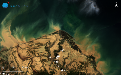
Indonesia’s Sumatra Floods and Landslides — Satellite Data Analysis
In late November 2025, a cataclysmic hydrometeorological disaster struck the Indonesian island of Sumatra. Torrential rainfall, associated with Tropical Cyclone Senyar, occurring during the peak of the monsoon season, triggered catastrophic flash floods and landslides...

SeaCras Joins CASSINI Business Accelerator: Croatia’s First Space Tech Startup Among Europe’s Top 20
SeaCras has been selected as one of only 20 space tech startups in Europe to join the CASSINI Business Accelerator Batch 6. This is notably a big success for Croatia, as SeaCras is the first domestic company ever to enter this program. The key quantifiers that led to...
Smart or Green Ports: Oxymoron or Complementarity?
In the age of digital transformation and climate urgency, the maritime sector stands at a crossroads. Are “smart” and “green” ports two sides of the same coin - or competing paradigms? The answer, as emerging global trends suggest, lies in their complementarity. From...