The World Wide Fund for Nature (WWF) has highlighted the urgent need to protect the Mediterranean’s Posidonia Oceanica meadows from damage caused by anchoring. So, how should we address the challenges of marine conservation?
The WWF’s report is based on satellite data from the Automatic Identification System (AIS) for tracking ships. But when it comes to AIS, there are a few things to keep in mind.
AIS only counts ships that are over 24 metres long and have the system turned on – and vessels over 24 metres long or more make up only a small part of the total sailing fleet. Most sailors who anchor are smaller vessels, mainly sailboats and catamarans.
Similarly, many ships over 24 metres long deliberately do not switch on their AIS systems (the so-called ‘dark vessels’) in order to avoid revealing their true routes and impact on the environment.
To demonstrate how much the study was not quite right in assessing the actual situation, we’ve visualised our analysis in the image below, which shows the relationship between the following areas:
- Red color – areas with Posidonia oceanica off the coast of Korčula island that are (partially) covered by the study.
- Green color – areas where the seagrass grows, and which are exposed to the anchoring of dozens of vessels, most often less than 15 meters long, on a daily basis.
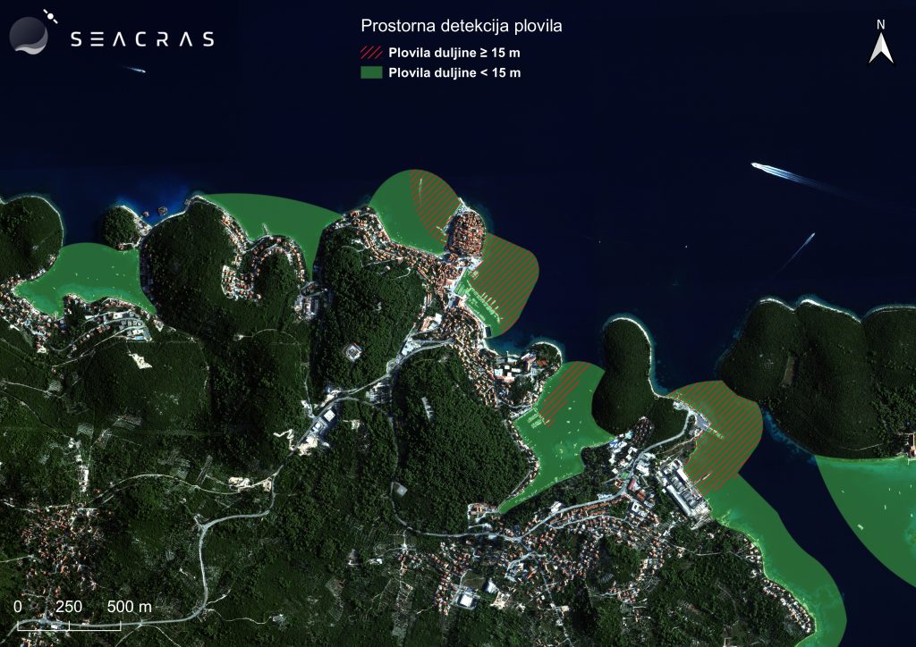
Vessel detection image based on our analysis
Looking only at the territory of the Republic of Croatia, it’s clear that the actual number of anchorings that negatively affect the marine environment – and thus undermine efforts toward marine conservation – is incomparably higher than that shown in the study.
We deliberately took vessels up to 15 meters long as a reference, and not up to 24 meters, because in that case the difference would be even more drastic and would further discredit the conclusions of the study.
Additionally, anchoring on Posidonia oceanica meadows represents only one of the key parameters for assessing the ecological vulnerability and maximum capacity of the area.
Here are some other questions for further discussion:
- What specific types of vessels are involved?
- How many such vessels are there exactly?
- To what extent and how do they affect the seabed?
- To what extent do they affect the quality of the sea?
- How much is plastic pollution and underwater noise?
- Where are the dark vessels?
- How does all of the above affect navigation safety?
- What is the preferential choice of destinations for foreign guests?
Is there any solution? We’ve got it, and it’s called Coastal Intelligence.
SeaCras uses Coastal Intelligence to analyse data from all vessel sizes. Including the detection of ‘dark vessels’, i.e. those with illegal maritime operations.
Based on our analysis, it is not surprising that the Republic of Croatia expanded the network of protected marine areas from the current 12% to 32%, with the announcement of the adoption of a national plan for the restoration of nature.
As an official member of the EU Mission: Restore Our Ocean and Waters, UN Global Compact Network and UN 1000 Ocean Startups initiatives, we welcome and support this decision and look forward to actively contributing to the coastal areas and marine conservation.
The Coastal Intelligence system covers not only impacts on seagrass meadows, but also bleaching and mechanical damage to corals, as well as mangrove clearing.
Only with active and integrated monitoring of various indicators of the actual situation and modelling of future scenarios, it is possible to recognise threats in a timely manner, prevent further environmental degradation and mitigate the consequences of human negligence.