In September 2024, we successfully finalized our project, Satellite Radar and Optical Oil Pollution Detection and Monitoring (E! 2,448: Sar2dem), funded by Eurostars, the Eureka Network, and Horizon Europe.
The R&D project lasted 18 months, with the goal of developing a system to detect oil spills in the inner territorial sea using both Sentinel-1 and Sentinel-2 data. The completion of the Sar2dem project marked the formal integration of oil spill detection models into our existing Coastal Intelligence portfolio of services.
Uniqueness of the Developed Technology
What makes our approach unique is that SeaCras has developed AI algorithms capable of processing Sentinel-1 and Sentinel-2 data to detect oil spills not only in territorial waters but also in complex coastal environments, such as Croatia, Greece, Turkey, and Southeast Asia. Most existing industry solutions are designed primarily for open waters. However, SeaCras’ solution overcomes this limitation.
Additionally, through our R&D activities, we identified the limitations of relying solely on open-source data, particularly in terms of temporal and spatial resolution. This presents a challenge when responding quickly to pollution incidents in coastal areas.
To address this, we integrated a series of commercial satellite data sources to enhance both temporal and spatial resolution, ultimately improving response times and strengthening the resilience of the maritime transport sector.
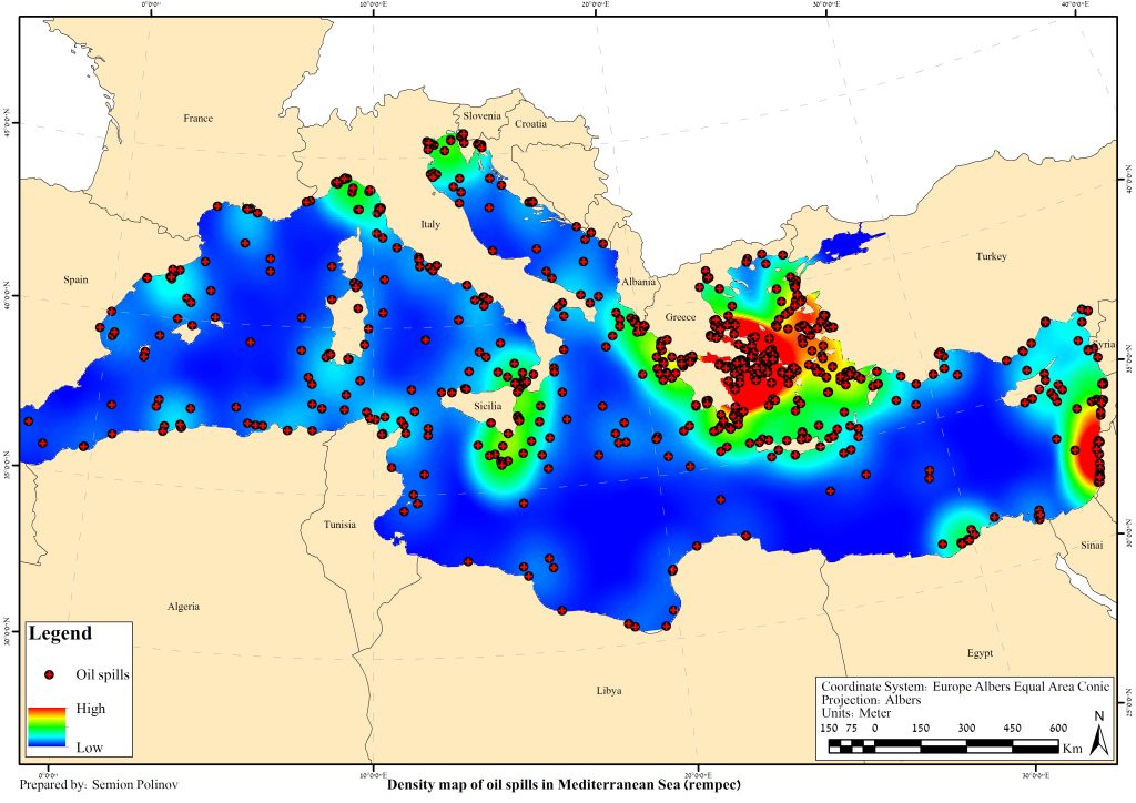
This is especially important considering that EMSA’s CleanSeaNet service in 2023 detected most potential incidents within areas smaller than two km². In contrast, SeaCras specializes in detecting pollution hazards as small as a few hundred square meters or less — this is fine detection at its best.
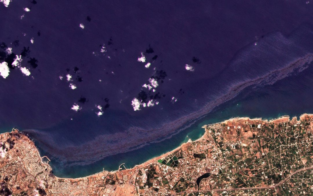
Oil spills occurrences in the Mediterranean Sea (adapted from: https://doi.org/10.1016/j.marpolbul.2021.112338)
Also, maritime transport contributes to water pollution through the emission of hazardous substances; primarily oil spills, but also through operational discharges such as grey water and waste from exhaust gas cleaning systems (ECGS). Also, the discharge of grey water has increased by 40% from 2014 to 2023, mainly due to the growth in cruise ship operations.
Building on these findings, we expanded our evaluation beyond acute pollution (such as oil spills) to include soft pollution, such as blackwater tank discharges and sewage water discharges from large vessels.
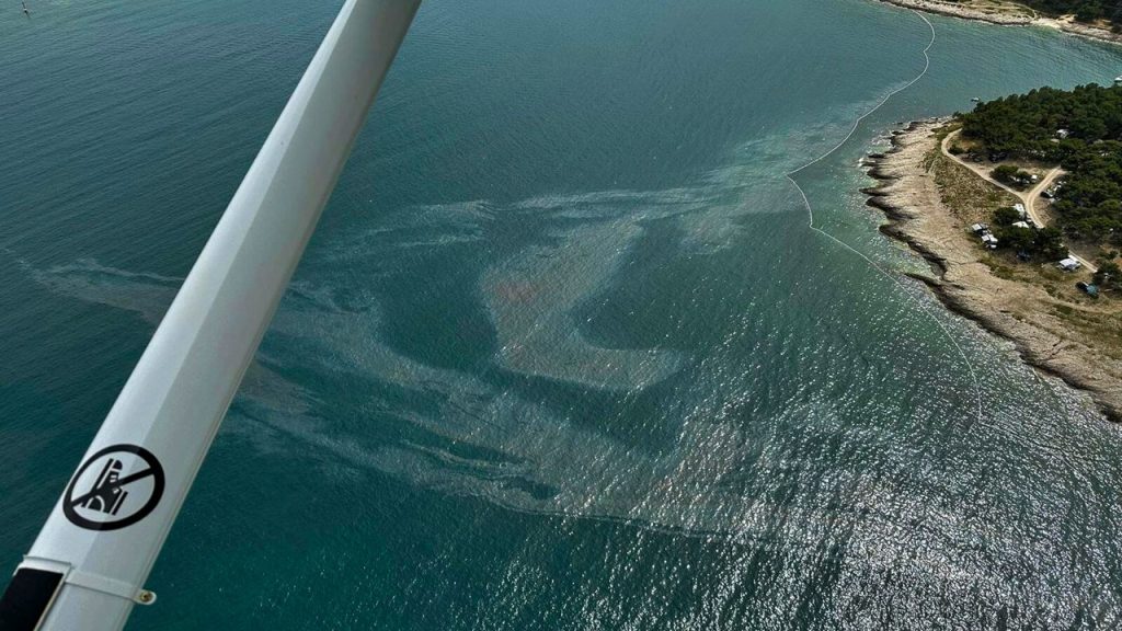
Aerial view of the oil spill off the coast of Premantura, Croatia.
SeaCras Technology Now Enables the Identification of Multiple Pollution Categories in Maritime Transport Sector:
MARPOL Annex I – Oil Pollution
MARPOL Annex IV – Sewage Pollution
MARPOL Annex V – Garbage Pollution
All this is made possible through the strategic use of AI-driven methods, a combination of diverse satellite data sources, and expertise in data and marine sciences.
The project funding and progress reporting were facilitated by the Croatian Agency for SMEs, Innovations, and Investments (HAMAG-BICRO).
Discussions about protecting the environment and preserving natural resources as well as warnings about the growing soil, air, and marine pollution, along with environmental degradation, is becoming an increasingly prominent topic in public discourse.
These initiatives, debates, and educational efforts are vital as they remind us of our responsibility to future generations. Through collective efforts, innovation, and sustainable practices, we can lay the foundation for a healthier and cleaner environment.
It’s expected that a quarry located near the coastline would have some impact on the seabed and water column. However, several questions remain:
1) Can we accurately assess the extent of this impact? 2) Can we provide quantitative evidence to support the term “ecocide”? 3) Moreover, is the damage localized, or does its influence extend far beyond?
Even a quick glance at Google Maps reveals that the shallow waters near the shore are covered in fine sediments originating from the quarry. Yet, beneath the surface lies a wealth of details that the naked eye cannot detect.
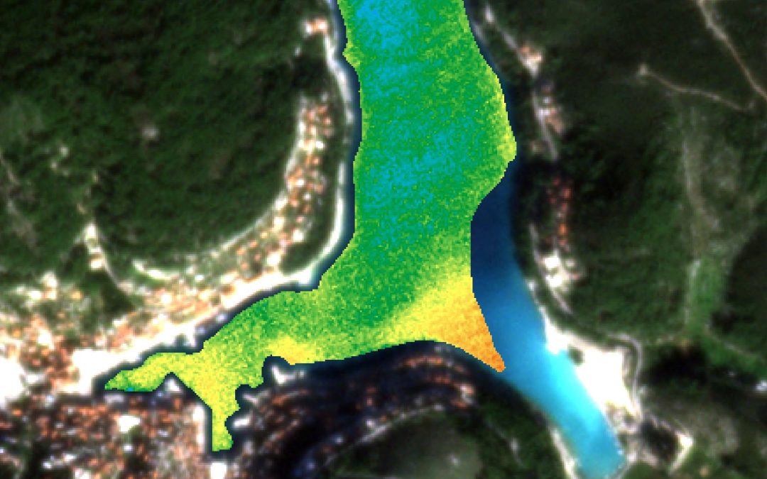
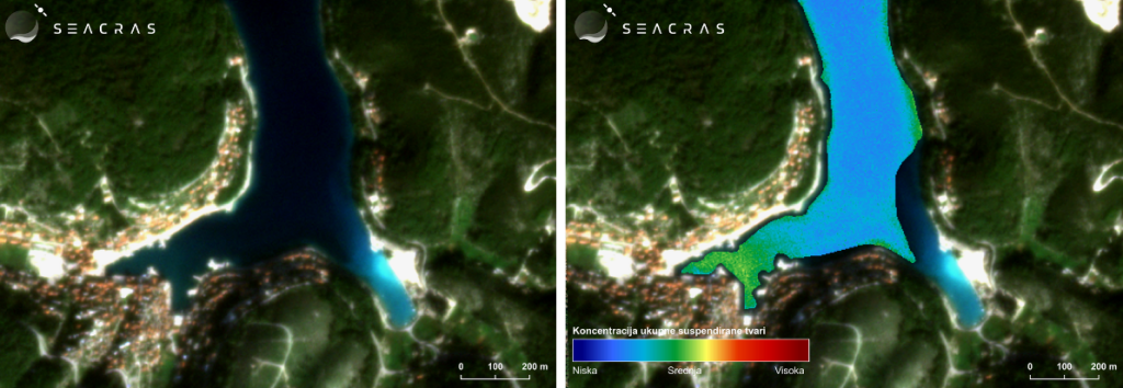
We conducted a study using our AI-powered analysis of high-resolution satellite data to examine the quarry’s impact on the marine water column. Some results are presented in images 1) and 2).
Image 1) Satellite image of the Pučišća area on the island of Brač (left) and a thematic map showing the quantitative measurement of suspended matter concentration in the water column using SeaCras AI algorithms, dated November 8, 2024 (right).
Image 1) shows a scenario of relatively calm weather with no wind.
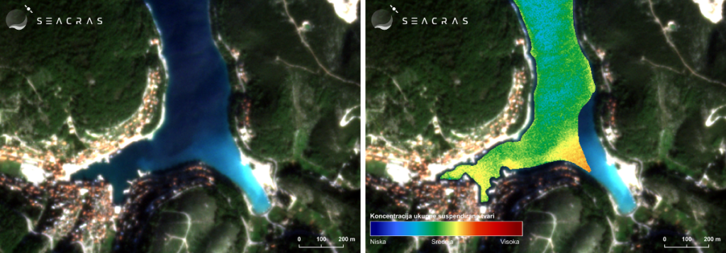
Image 2) Satellite image of the Pučišća area on the island of Brač (left) and a thematic map showing the quantitative measurement of suspended matter concentration in the water column using SeaCras AI algorithms, dated November 15, 2024 (right).
Image 2) depicts conditions under the influence of strong bora wind, blowing from the northeast (NE), across the wider area of the island Brač.
The true scope of the problem becomes evident in image 2). The results from our AI analysis quantitatively demonstrate a dramatic increase in suspended matter concentration in the water column. The measured concentration of suspended matter in the middle of the bay (image 2)) is five times higher than that observed in image 1), on dates where there is no wind. Furthermore, near the southern shore, this increase exceeds tenfold.
Additionally, the zone of impact is quantifiable and encompasses the entire bay, revealing a much broader area of influence than what local residents might observe!
The root cause of this issue, which likely occurs periodically, is the strong bora wind carrying material from the quarry located on the northeastern side of the island. The bora spreads this material across a wider area, with a significant portion ending up in the sea, covering the entire bay with substantial deposits.
This natural phenomenon of marine pollution is further exacerbated by urbanization, which often results in larger amounts of inadequately managed construction and industrial waste. This compromises seawater quality and disrupts the natural balance of the marine ecosystem. Our solutions for detecting and monitoring marine turbidityleverage advanced satellite technology and data analytics to precisely track the impacts of such events. This enables timely access to critical information necessary for implementing environmental conservation measures and sustainable coastal management.
Over the years, the cumulative effect has been devastating to the marine environment, as deposits ‘smother’ the seabed and degrade its habitat. While physicochemical indicators of seawater quality periodically point to poor conditions, microbiological quality remains unaffected by these influences.
Using our technology, we addressed all the aforementioned questions and concluded that this represents a form of slow ecocide. However, it is also crucial to recognize that traditional environmental and impact assessments, while based on textbook knowledge, often fail to anticipate unexpected scenarios, particularly in the context of climate change.
Effectively addressing the devastation of marine ecosystems, the impacts of human activities, climate change, pollution, and the degradation of the biosphere on a broader scale requires a comprehensive and strategic approach. Key components of such an approach include continuous monitoring, trend analysis, and the prediction of future scenarios, all grounded in the use of advanced technologies like environmental digital twins. These tools enable precise tracking, comparison, and modeling of future impacts, providing a solid foundation for sustainable and effective decision-making.
SeaCras, in partnership with Smeco AS, is currently conducting a bilateral project titled ‘Feasibility Study for SeaCras’s Earth Observation-Enabled Products to Foster Sustainable Blue Growth and Norway’s Coastal Tourism’. This project is funded by Innovation Norway under the name ‘Bilateral Cooperation in Green and Blue Sectors Between Croatia and Norway’.
The project’s goal is not only to test the value proposition of SeaCras products, designed and developed for stakeholders in the cruising industry, maritime transport, and coastal tourism, but also to complement it with an actual demonstration study of marine emissions across a network of locations, including ports, fjords, and protected marine areas.
Through the implementation of the SeaCras system across multiple locations in Norway, along with Smeco AS’s network connections and dissemination activities, a groundbreaking large-scale study of marine emissions from cruise ships and port operators across entire destinations is being developed and articulated among stakeholders. The new era of sustainable business demands that environmental assessments be integrated into business models. Consequently, feasibility studies as strategic documents must evolve to reflect this shift.
SeaCras’s unique value lies in its ability to monitor dozens of locations simultaneously. This capability provides an unparalleled perspective on the interplay between cruising and tourism business operations and their impact on the marine environment in Norwegian fjords, bays, and coastlines.
Studies like this will be crucial for the sustainable development of the cruising industry. Future projects will expand to large-scale studies in the Adriatic, Mediterranean, Caribbean, Red Sea, and beyond.
As promised, part of the results will be published in the UN Ocean Prediction Atlas to encourage community involvement in conservation and restoration projects, as well as to promote open data and open science practices.
We extend our gratitude to Innovation Norway for their support through grants, mentorship, and continuous collaboration.
SeaCras was invited to deliver a presentation on December 11, 2024, at the workshop Strengthening Tourism Resilience to Climate Change organized by the Ministry of Tourism and Sports of the Republic of Croatia. The goal of the workshop was to raise awareness among tourism professionals about the impacts of climate change, its associated risks, and adaptation opportunities to strengthen the resilience of local communities.
The target audience for the workshop included tourism stakeholders, potential investors, owners of tourist facilities, project managers and technical experts, the scientific and professional community, local residents, and the general public.
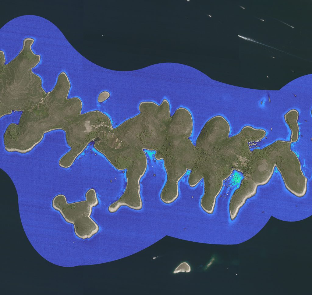
Image 1. AI analysis of marine conditions at Paklinski Islands, Croatia. The Paklinski Islands are one of the most attractive destinations for sailors and boaters.
Our presentation, titled Documenting and Evaluating Tourism’s Impact on the Marine Environment: AI Data Analysis, focused on demonstrating how a better understanding of data can help enhance tourism resilience to climate change. We highlighted specific, successful examples from our Adriatic partners, such as cruise ports in Dubrovnik, Korčula, and Zadar, as well as protected areas like Telašćica Nature Park and Brijuni National Park.
We showcased the functionality of some of our products, including the SeaCras app — an innovative marketing tool designed to demonstrate investments in the sustainability of destinations and marine ecosystems — and our ESG reporting services tailored for coastal tourism stakeholders.
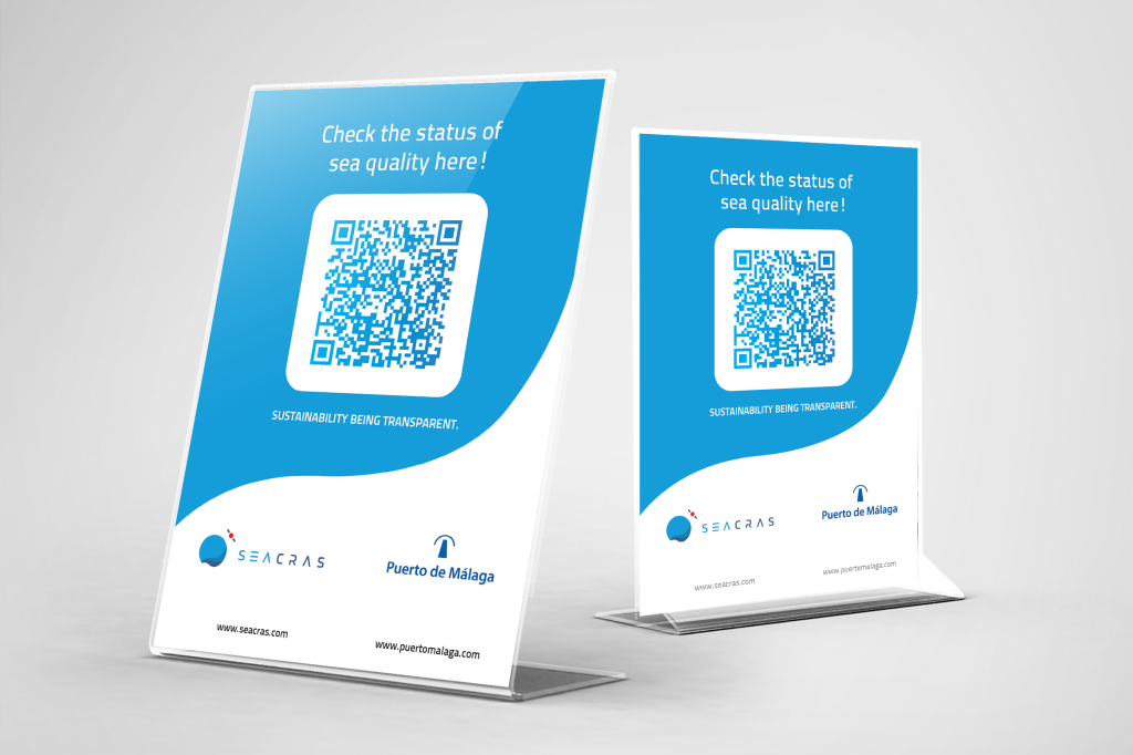
Image 2. Flyer with a QR code for accessing the SeaCras application, launched in the port of Málaga.
Behind the user-friendly interface of the SeaCras application, designed to engage all age groups of guests and local residents, lies complex and robust AI analysis of various environmental datasets — covering marine, atmospheric, and coastal conditions. First developed in 2020, the application is now used by a growing number of tourism stakeholders across three continents. Tourism stakeholders who can immediately benefit from our application include hotels, resorts, seaside campsites, marinas, and beach concessionaires.
We view it as a positive development that climate security and environmental sustainability are increasingly becoming part of the business practices of tourism stakeholders and a more significant topic among local communities. And technology plays a critical role in supporting this transition.
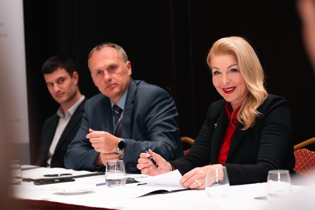
SeaCras’ CEO, Mario Špadina, joins the Board of Directors of the International Institute for Climate Action (IICA), an association SeaCras has been part of since 2024!
Except for Mario as the newest member of the Board, the IICA Assembly has elected and warmly welcomed another new member, Jakov Kolega, CEO of Greengreen Advisory as well. Jakov and Mario joined the re-elected members Javier Manzanares Allen and Goran Romac, under the leadership of President Marija Pujo Tadić
This team, without doubt, forms an outstanding team that will continue to fight against climate change by reducing CO2 emissions and promoting other actions to mitigate climate change risks.
The IICA’s vision is to make Europe the first climate-neutral continent by 2050 through collaboration of all sectors and business communities, and we’re very grateful to be part of this group.
So how does the IICA plan to make this ambitious goal happen? Here are the main goals and the association’s activities:
The IICA is committed to advancing a comprehensive strategy to tackle climate change by promoting mitigation efforts and encouraging public awareness about the dangers of carbon footprints. By promoting CO2 reduction solutions and advocating for air and ozone layer protection, IICA aims to inspire proactive environmental protection and sustainable development.
Through encouraging the accelerated adoption of the Low Carbon Strategy and the Climate Change Adaptation Strategy, IICA also strives to drive faster economic progress while supporting the implementation of critical frameworks like the Climate Act and the European Green Plan.
This is exactly why Mario is the perfect fit to be part of the Board of Directors of IICA, as he has proven numerous times his advocacy for sustainability of the blue economy and climate security, raising public awareness on ongoing climate change effects of biosphere, and increasing environmental literacy in the business sector.
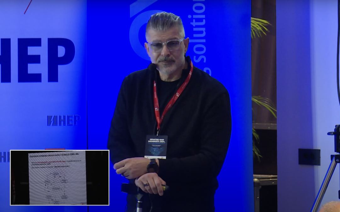
On October 16, 2024, our Chief Science Officer, Associate Professor Robert Kopal, PhD, had the honour and privilege of being an invited keynote speaker at the Croatian Days of Security 2024, having held the lecture titled “Climate Security – Causes and Consequences.”
Climate change exacerbates food, water, and livelihood insecurity, triggering cascading effects such as heightened competition for natural resources, social disruption, and displacement. These dynamics can lead to increased tensions, conflicts, and instability in specific countries or regions. The concept of climate security focuses on understanding how the climate crisis impacts peace and security.
The Key Focus of the Lecture Dr. Kopal’s work on this lecture began a year ago, with a core goal of answering critical questions about the points where climate and environmental challenges intersect with security.
The event was organized by the Croatian Association of Security Managers, which also announced the lecture.
The core premise of the lecture underscores that climate security is about the impacts of the climate crisis on peace and security, particularly in fragile, conflict-affected settings.
It explored three key dimensions:
1) Climate Change: Security Climate change exacerbates food, water, and livelihood insecurity, with cascading effects such as increased competition for resources, social unrest, and displacement. These factors can lead to heightened tensions, conflicts, and instability in countries or regions.
2) Security: Climate Change In conflict-affected areas, the impacts of climate change can intensify or prolong conflicts, making peacebuilding and stability more challenging.
3) Security: Climate Change Conflict can disrupt or obstruct climate action, including destruction of critical resources (energy, water, agriculture) or delaying mitigation and adaptation efforts.
To help navigate the lecture, here are key timeline markers:
What is climate security?
Common climate-induced risks to peace and security
Data-driven insights
Jablanica disaster and a potential ecological challenge in Croatia
WEF 2024: Current risk landscape
What will the climate feel like in 60 years?
Global risks interconnection map
Climate security & climate change interplay
Beyond the Eye of the Storm: Pathways to security implications
Causal Loop Diagram (CLD) insights
Somalia famine scenario analysis (1983/84)
Security dilemma examples
Arctic ice-albedo feedback effects
Game theory perspectives on global climate change
EU ETS overview
Digital twins and “Destination Earth” initiatives
High-resolution satellite data analysis using AI
Marine blooms of 2024
Winners of the Regenerative Blue Economy Challenge (WEF 2024)